.png)
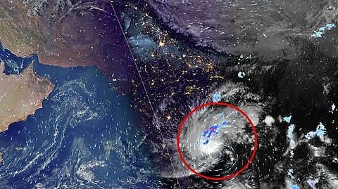
Third cyclone in a month set to hit India, ISRO satellites capture massive storm buildup
India's eastern coastline is bracing for another powerful cyclonic storm, with the India Meteorological Department (IMD) forecasting that a deep depression over the Bay of Bengal could intensify into a very severe cyclonic storm before crossing the Andhra Pradesh coast on November 20.
If the system develops as predicted, it will be the third cyclone to affect India in less than a month, following Cyclone Arnab and Severe Cyclonic Storm Murasu, which struck the eastern coast earlier in the post-monsoon season.
Satellite observations from the Indian Space Research Organisation's INSAT-3DS and INSAT-3DR satellites have revealed extensive cloud formations over the southeast and adjoining southwest Bay of Bengal, indicating intense atmospheric activity associated with the developing weather system.
Thermal infrared imagery captured by INSAT-3DS between 5 pm and 5.27 pm on Monday showed a dense concentration of clouds over the sea.
Another set of images recorded by INSAT-3DR between 4.15 pm and 4.42 pm revealed widespread cloud bands extending across the central and southern Bay of Bengal.
The satellite observations come as the IMD monitors the system's movement and potential intensification ahead of its expected approach towards India's eastern coastline.
𝗦𝘁𝗼𝗿𝗺 𝗹𝗶𝗸𝗲𝗹𝘆 𝘁𝗼 𝗶𝗻𝘁𝗲𝗻𝘀𝗶𝗳𝘆
According to the IMD, the deep depression moved north-northwestwards at approximately 17 kmph during the six hours preceding 11.30 am on November 16.
At that time, the system was positioned over the southeast and adjoining southwest Bay of Bengal, around 650 km east-southeast of Chennai, 730 km south-southeast of Visakhapatnam and 850 km south of Gopalpur in Odisha.
The weather department forecast that the depression was very likely to develop into a cyclonic storm over the central parts of the south and adjoining west-central Bay of Bengal by Monday evening.
It was subsequently expected to strengthen into a severe cyclonic storm by the evening of November 17 before intensifying further into a very severe cyclonic storm.
The system is forecast to move west-northwestwards towards the eastern coastline and cross the Andhra Pradesh and Yanam coast between Nellore and Tuni around noon on November 20.
At the time of landfall, maximum sustained wind speeds are expected to reach 120–130 kmph, with gusts of up to 145 kmph.
𝗖𝗼𝗮𝘀𝘁𝗮𝗹 𝗮𝗿𝗲𝗮𝘀 𝗼𝗻 𝗮𝗹𝗲𝗿𝘁
The IMD has issued a pre-cyclone watch for Andhra Pradesh and the adjoining south Odisha coast, placing the region under a yellow message as the weather system develops.
The alert comes amid concerns over the possibility of another spell of severe weather along the eastern coast, which has already experienced two cyclonic storms in recent weeks.
The anticipated strengthening of the system could bring strong winds, heavy rainfall and rough sea conditions to vulnerable coastal areas.
The storm's eventual impact will depend on its precise trajectory, intensity and rainfall distribution as it approaches land.
Weather authorities are continuing to monitor satellite observations and changes in the system's movement to assess the potential risks to coastal communities.
The latest forecast places the Andhra Pradesh coast at the centre of the anticipated landfall, although changes in the storm's track and strength remain possible as the system develops over the Bay of Bengal.


