.png)
Cyclone Arnab intensifies over Bay of Bengal, Andhra Pradesh and Odisha step up preparations
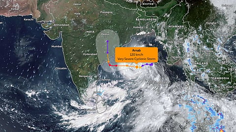
Cyclone Arnab has intensified over the Bay of Bengal, with satellite imagery from India’s INSAT-3DS weather satellite showing intense convective cloud activity as the storm moves towards the eastern coastline. The India Meteorological Department (IMD) has warned that the system is likely to strengthen into a very severe cyclonic storm before making landfall along the Andhra Pradesh coast on October 28.
In its satellite bulletin issued at 8.30 am IST on Monday, October 26, the IMD placed the cyclone’s centre near 15.4°N latitude and 88.5°E longitude over the east-central and adjoining west-central Bay of Bengal. The system had moved westwards at approximately 15 kmph during the preceding six hours.
At the time, the cyclone was around 610 km east-southeast of Visakhapatnam, 690 km east-southeast of Kakinada and 580 km southeast of Gopalpur in Odisha.
The IMD expects the storm to intensify into a severe cyclonic storm by midnight on October 26 and a very severe cyclonic storm on October 27. It is then likely to move northwestwards and cross the Andhra Pradesh and Yanam coast between Bapatla and Visakhapatnam, close to Yanam, by the forenoon of October 28.
The cyclone is forecast to make landfall with maximum sustained wind speeds of 115-125 kmph, with gusts reaching up to 140 kmph. The IMD has issued a red-message cyclone warning for Andhra Pradesh and the adjoining south Odisha coast.
INSAT-3DS imagery tracks intense cloud activity
The latest satellite assessment shows scattered to broken low- and mid-level clouds, with embedded intense to very intense convection over the central and southern Bay of Bengal.
These cloud formations indicate vigorous thunderstorm activity associated with the developing cyclone. Satellite observations are particularly important for tracking the storm’s position, cloud organisation and convective development over the sea, where direct weather observations are limited.
As the system strengthens, the IMD expects heavy to very heavy rainfall, with extremely heavy rainfall possible at isolated locations in affected areas. Strong winds and rough to very rough sea conditions are also expected to create risks for coastal communities, fishing vessels and maritime activities.
The IMD has additionally warned of a storm surge of around 1 to 1.5 metres above the astronomical tide in low-lying areas of Andhra Pradesh during landfall. The maximum surge is expected near Kakinada and Yanam, raising concerns about coastal inundation.
Andhra Pradesh braces for landfall on October 28
The expected landfall zone lies along the Andhra Pradesh and Yanam coastline between Bapatla and Visakhapatnam. The cyclone is forecast to turn northwestwards as it approaches the coast after moving west-northwestwards over the Bay of Bengal.
The IMD has warned of heavy to very heavy rainfall, with extremely heavy rainfall possible at isolated locations in parts of Andhra Pradesh. Gale-force winds, rough seas and the possibility of coastal inundation could disrupt normal activities in vulnerable areas.
Authorities are expected to monitor weather developments closely as the cyclone approaches the coast. Fishermen and maritime operators face particular risks from worsening sea conditions, while residents in low-lying coastal areas could be affected by heavy rain, strong winds and storm surge.
The forecast intensity and landfall location remain subject to updates as the system develops, with the IMD continuing to track the cyclone through satellite observations and weather bulletins.
Odisha intensifies precautionary measures
Although the forecast landfall is along the neighbouring Andhra Pradesh coast, Odisha has stepped up its preparations because the cyclone could bring heavy rainfall and strong winds to parts of the state.
The Odisha government has prohibited fishing activities in the sea and barred tourists from visiting hills, waterfalls, dams and scenic destinations in six vulnerable districts: Ganjam, Gajapati, Rayagada, Malkangiri, Koraput and Nabarangpur.
Chief Minister Mohan Charan Majhi has deputed eight ministers to monitor preparedness in different areas. Teams from the National Disaster Response Force (NDRF), Odisha Disaster Rapid Action Force (ODRAF), Fire and Emergency Services and the police have been positioned in vulnerable locations.
According to state officials, 24 ODRAF teams and six NDRF teams have been deployed to support emergency response and rescue operations.
Schools, colleges and Anganwadi centres in the six districts are scheduled to remain closed on October 28 and 29. Authorities are also moving residents of thatched houses and low-lying areas to safer shelters, while pregnant women are being shifted to healthcare facilities in advance.
The state government has cancelled leave for employees in the identified districts and established control rooms to coordinate emergency operations.
Officials have also been directed to ensure that vulnerable residents can access safe shelters and essential services as the cyclone approaches. The administration is monitoring the evolving weather situation and preparing for possible disruptions caused by heavy rainfall, strong winds and flooding.
With Cyclone Arnab expected to intensify further over the Bay of Bengal before reaching the coast, Andhra Pradesh and Odisha are continuing their preparations to minimise the potential impact on residents, infrastructure and livelihoods.


